What Does the Mount Bromo Caldera Look Like From Above?
Key Takeaways:
- A vast “Sea of Sand” creates an alien, monochromatic floor.
- Mount Batok provides a sharp, symmetrical visual contrast.
- Mount Bromo is the only active, venting peak inside the basin.
- The viewpoint at Penanjakan 1 offers the most iconic “top-down” perspective.
About This Guide: Written by our Banyuwangi-based local operational team with first-hand field experience across East Java, including current trail conditions, departure timing, weather shifts, and real visitor logistics.
Table of Contents
The Anatomy of the Tengger Caldera
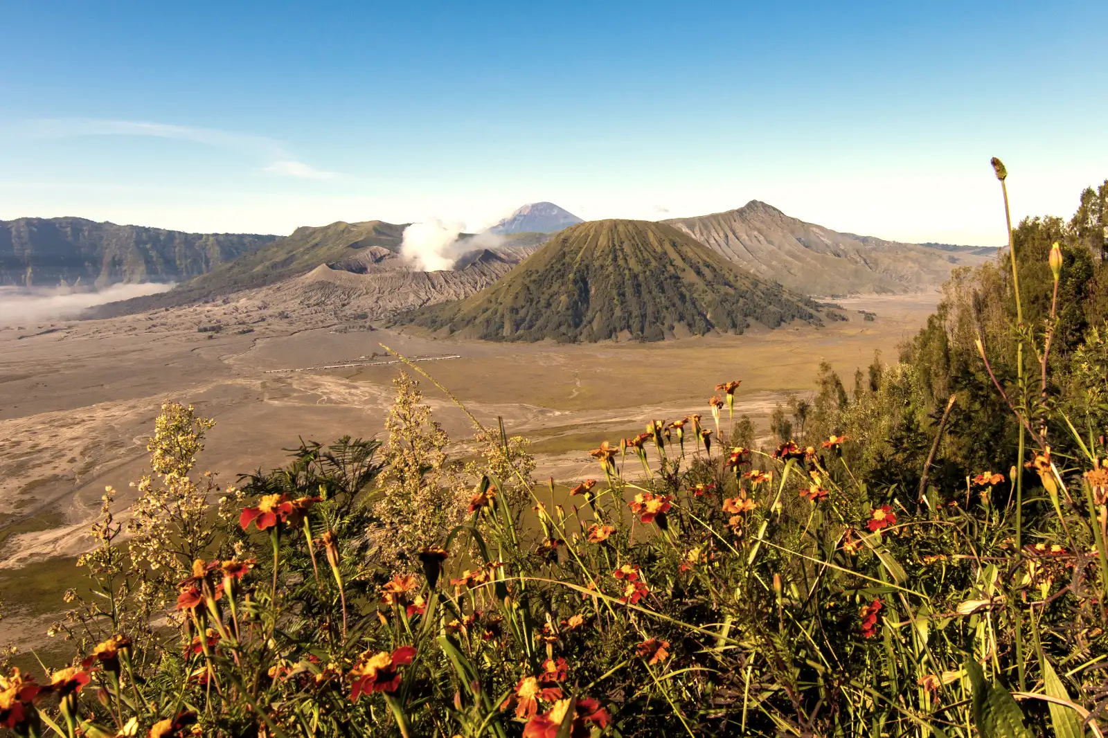
Look, the word “volcano” usually brings to mind a single peak. But Bromo is different. It sits inside the Tengger Caldera, a giant volcanic crater formed thousands of years ago. When you look at it from above, you aren’t just looking at one mountain; you are looking at a “complex” of peaks rising from a flat, sandy wasteland.
The caldera floor sits at roughly 2,100 meters above sea level. From the rim, the drop-off is dramatic. The sheer scale of the Bromo Tengger Semeru National Park becomes obvious once you gain elevation. It feels like looking down at another planet where the laws of greenery and life don’t quite apply in the same way.
The Visual Experience From Above
If you ask me, the most striking thing is the color palette. Most of the Indonesian landscape is deep emerald green. However, the Bromo caldera is dominated by ash-gray and charcoal-brown. This creates a stark, beautiful desolation. At dawn, the shadows stretch across the Segara Wedi (Sea of Sand), making the ripples in the volcanic dirt look like waves in an ocean.
The Three Central Icons
From a high vantage point, your eyes will settle on three main shapes. First is Mount Batok. It is dormant, perfectly symmetrical, and covered in folded green ridges. Right next to it is Mount Bromo. Bromo is shorter, rugged, and has its top “blown off.” It’s constantly puffing white sulfurous smoke. Finally, there is Mount Widodaren, which sits quietly in the background.
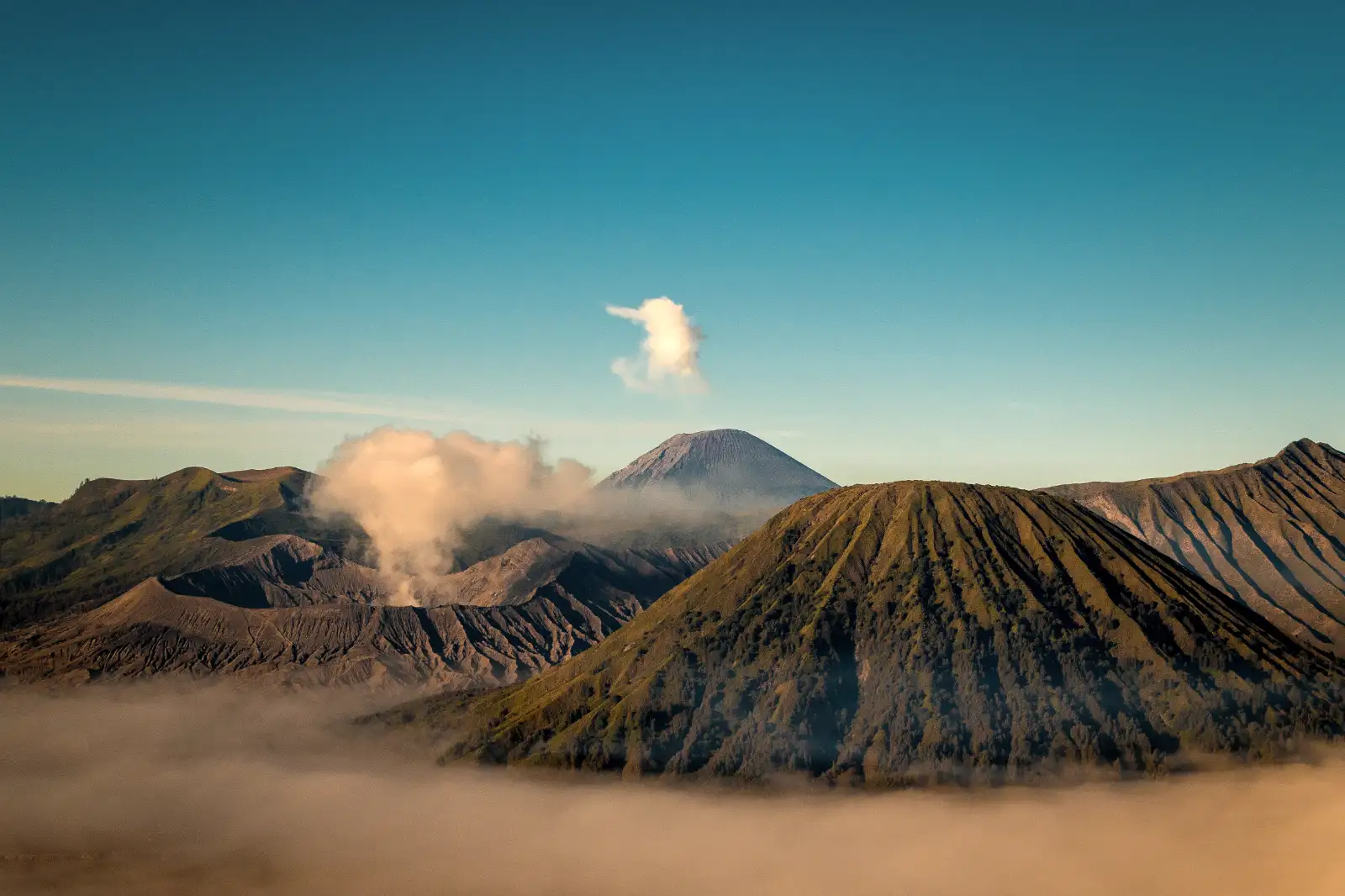
The contrast between the smooth lines of Batok and the jagged, smoking mouth of Bromo is what makes this view world-famous. It is a textbook example of the geological story behind Mount Bromo. You can see exactly how the earth collapsed to form this giant bowl.
The Cloud Inversion
On many mornings, the entire caldera floor is filled with a thick layer of white mist. From above, it looks like the volcanoes are floating on a sea of clouds. This phenomenon is a major driver of the Fear of missing out among photographers. When the sun hits that mist, the whole caldera glows in shades of orange and pink.
Best High-Altitude Viewpoints
To see the caldera from above, you have to climb the surrounding rim. The most popular spot is Penanjakan 1. At 2,770 meters, it puts you nearly 700 meters above the caldera floor. It’s the classic “postcard” view where you can see the entire alignment of peaks all the way to Mount Semeru in the distance.
For those who want a slightly different angle, King Kong Hill is a fantastic alternative. It’s lower than Penanjakan but closer to the caldera edge, making the volcanoes feel much larger and more imposing. You can almost hear the roar of the Bromo crater from here on a quiet morning.
If you prefer a more intimate “top-down” look at the crater itself, you should take a Mount Bromo tour that includes the rim walk. Standing on the very edge of the Bromo crater allows you to look vertically down into the bubbling, steaming vent. It’s terrifying and beautiful at the same time.
Practical Information
Getting these views requires some logistics. You can’t just drive a regular car into the caldera floor; a 4WD Jeep is mandatory for the Sea of Sand. Most people start their journey from Probolinggo or Malang in the middle of the night to reach the viewpoints before the sun comes up.
- Location: Bromo Tengger Semeru National Park, East Java.
- Highest Viewpoint: Penanjakan 1 (2,770m).
- Best Time: 05:00 AM to 07:00 AM for the best light.
- Required: National Park Entrance Ticket (booked online).
- Temperature: 3°C to 10°C in the early morning.
Viewpoint Comparison
| Location | Best For | Height | Accessibility |
|---|---|---|---|
| Penanjakan 1 | Full Panoramic View | 2,770m | Jeep Access + Short Walk |
| King Kong Hill | Photography/Less Crowds | 2,650m | Jeep Access + Steep Hike |
| Seruni Point | Budget/Local Access | 2,400m | Stairs from Cemoro Lawang |
| Bromo Rim | Inside the Crater View | 2,329m | 250 Stairs + Sand Hike |
Local Tips You Should Know
Truth is, the “perfect” view depends on the wind. If the wind is blowing the smoke from Bromo toward the viewpoints, the caldera can get hazy. This is why we usually recommend staying for at least two nights if you are a serious photographer. Also, check out the ultimate guide to sunrise viewpoints to pick the right spot for your fitness level.
One more thing: the caldera is dusty. Really dusty. From above, you can see the dust clouds kicked up by the Jeeps. If you have asthma or sensitive eyes, bring a mask and goggles even if you are just standing at the viewpoints. The volcanic ash is fine and gets everywhere.
Frequently Asked Questions
Q: Can I see the caldera without hiking?
A: Yes. You can reach Penanjakan 1 by Jeep, and the walk to the viewing platform is paved and relatively flat. It’s the easiest way to see the “top-down” view without breaking a sweat.
Q: Is the view different in the rainy season?
A: Honestly, it’s greener. The caldera floor stays gray, but the surrounding mountains turn a lush emerald color. However, the risk of clouds blocking the entire view is much higher.
Q: What is the best way to get there from Surabaya?
A: Most travelers book a Mount Bromo tour from Surabaya which includes a midnight pickup, Jeep rental, and a local guide to navigate the viewpoints.
Q: Can I fly a drone over the Bromo caldera?
A: Drones are allowed but require a permit and a fee. The wind inside the caldera can be very unpredictable, so be careful. It’s a great way to see what the Mount Bromo crater looks like from a vertical angle.
Q: Why does the caldera look like a sea?
A: It’s because of the “Sea of Sand” (Segara Wedi). The fine volcanic sand is so vast and flat that from a distance, the wind creates patterns that look exactly like ocean ripples.
Recommended Tour Packages
- Classic Mount Bromo Day Tour: The essential experience covering the sunrise viewpoints and the crater walk.
- Surabaya to Bromo 2D1N: A comfortable pace with an overnight stay in Cemoro Lawang for the best caldera views.
- Bromo & Ijen Adventure: Combine the sandy caldera of Bromo with the acidic blue flames of Ijen Crater.
- Malang to Bromo Midnight Trip: The quickest way for travelers based in Malang to see the sunrise.
- Ultimate East Java Loop: See Bromo from above, plus the massive Tumpak Sewu waterfall.
Final Takeaway
Seeing the Mount Bromo caldera from above is a bucket-list moment for a reason. It is one of the few places on Earth where you can see the sheer power of volcanic geography so clearly. Whether you are standing on Penanjakan 1 or peering over the rim of the crater itself, the scale is something that photos can’t fully capture. It’s raw, dusty, and absolutely beautiful.
Planning Your Trip to East Java?
Explore our local tour options and choose a route that matches your travel schedule.