How Difficult Is the Ijen Crater Hike for Beginners?: Master Guide

Standing at the Paltuding basecamp trail at 2 AM, the air doesn’t just feel cold—it bites. You’re surrounded by hundreds of flickering headlamps, the smell of cheap clove cigarettes, and the distant sound of diesel engines idling in the dark. Most travelers arriving here have one burning question: just how difficult is the Ijen Crater hike for beginners? You’ve likely seen the stunning Instagram photos of the electric blue flames and the turquoise acid lake, but the platform rarely shows the gasping breath, the burning calves, and the thick, suffocating sulfur clouds. Is it a walk in the park or a vertical struggle? The short answer is that it’s manageable, but it demands respect for the volcano’s unique environment.
Planning this journey often feels overwhelming. Between securing reliable transportation from Bali and worrying about whether your fitness level for Ijen is sufficient, the logistics can be a headache. You don’t want to show up underprepared only to turn back halfway. We believe everyone should experience this otherworldly landscape, which is why we suggest you lock in your reservation with experts who handle the gear, the timing, and the safety protocols. This allows you to focus on the climb rather than the chaos of midnight logistics. If you’re looking for the complete picture of this volcanic giant, start with our comprehensive Ijen Crater tour guide to understand the full scope of the adventure.
What You Need to Know
If you’re looking for the “too long; didn’t read” version, here is the reality of the Ijen trek:
- Total Distance: Approximately 3 kilometers (1.8 miles) to the rim, one way.
- Incline: The first 2 kilometers are a steady, steep incline on a wide, sandy path. It is tiring but not technical.
- The Descent: Going down into the crater for the Blue Fire is the hardest part. It’s rocky, slippery, and involves dodging sulfur miners.
- Sulfur Gas: High-quality gas masks are mandatory. The wind can shift at any second, engulfing you in thick, white smoke.
- Cheat Code: Local “trolley taxis” are available if your legs give out, though they aren’t cheap.
Why Trust This Guide
We aren’t just writers sitting in an office; we are local operators based in East Java who live and breathe these volcanic trails. Our teams are at the Paltuding basecamp every single night, checking the weather, monitoring the sulfur gas safety levels, and chatting with the rangers. We’ve seen thousands of beginners reach the summit—some with ease, others with a lot of sweat and a few tears. This guide is built on real-world data and the collective experience of guides who have climbed Ijen over 500 times. We know exactly where the path gets slippery and which hour the wind usually shifts.
Volcanic activity is inherently unpredictable. One day the crater is a peaceful turquoise mirror; the next, it’s a roaring vent of toxic gas that forces the rangers to close the trail. Our deep connection with the local community and the Smithsonian Global Volcanism Program data ensures we provide advice that isn’t just inspiring, but safe. We’ve helped luxury travelers who haven’t hiked in years and hardcore backpackers on a budget. We know the nuances of the “Ijen struggle” better than anyone else.
The Trail Breakdown: Step-by-Step
The hike begins at an elevation of about 1,850 meters. When the gates open—usually around 2 AM—there is a sudden rush of adrenaline. You start on a very wide, well-maintained dirt path. For the first kilometer, the incline is gentle, almost deceptive. You’ll think, “This is easy!” But then, the real climb begins. The second kilometer is the “heart-breaker.” It is a sustained, steep incline with no flat sections to catch your breath. The dirt here can be loose, making you feel like for every two steps forward, you slide half a step back. This is where most beginners start to question their life choices.
The Final Stretch to the Rim
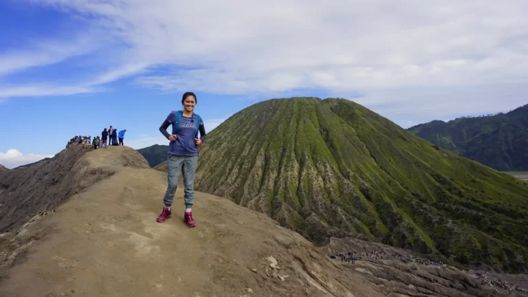
After about 70 to 90 minutes of uphill slog, the trail finally levels out. You’ll reach a small local canteen (Warung) where sulfur miners weigh their loads. This is the perfect spot for a quick rest and a hot tea. From here, the walk to the actual crater rim is mostly flat and incredibly scenic. As the sulfur crater rim elevation reaches approximately 2,386 meters, the vegetation disappears, replaced by twisted, dead trees and a landscape that looks like the surface of the moon. The wind picks up here, and you’ll likely start smelling the faint, rotten-egg scent of sulfur.
The Reality of the Rim
Once you reach the rim, the view is spectacular, even in the dark. You can see the stars clearly, and below you, the glowing Blue Fire might be visible. If you choose not to go down into the crater, the hike is essentially a very steep walk. It’s physically demanding on the lungs and legs, but there is no technical climbing involved. For most healthy beginners, reaching the rim is a 2-hour journey. The path is wide enough that you never feel like you’re going to fall off a cliff, which is a big relief for those with a fear of heights.
If you’re planning a trip through East Java, don’t stop at just one volcano. Most travelers find that a dedicated Ijen Crater tour is the perfect companion to a Mount Bromo tour. For the ultimate experience, our Bromo Ijen tour packages cover everything from transport to accommodation. If you have more time to explore the hidden waterfalls and coffee plantations of the region, check out our broader East Java tour options. We handle the stress so you can enjoy the views.
Fitness Level for Ijen: Do You Need to Be an Athlete?
You don’t need to be a marathon runner to conquer Ijen. However, if your only exercise is walking from the couch to the fridge, you’re going to find it difficult. The trail is essentially a 45-degree ramp for over a mile. It’s a test of cardiovascular endurance more than anything else. If you can walk for 5 kilometers on flat ground without needing a long nap, you can likely finish the Ijen hike. The key is pacing. Don’t try to race the local miners—they have calves of steel and are carrying 80kg of sulfur. Take slow, steady steps and stop whenever your heart rate feels like it’s redlining.
Age and Accessibility
We’ve seen travelers in their 70s reach the summit, and we’ve seen fit 20-year-olds struggle because they went too fast too early. The high altitude means there is less oxygen, so you’ll feel out of breath much quicker than at sea level. If you have pre-existing knee issues, the descent will be your biggest challenge. The steep downhill puts a lot of pressure on the joints. Bringing trekking poles is a fantastic “cheat code” for beginners to save their knees. For those with asthma or severe respiratory issues, the sulfur gas is a serious consideration that should be discussed with a doctor before booking.
The Hidden Danger: Descending for the Blue Fire
If the hike to the rim is a “medium” difficulty, the descent into the crater is “high.” This is where things get real. You are no longer on a wide dirt path; you are on a narrow, jagged trail made of volcanic rocks. You’ll be going down about 150 meters into the caldera. It’s dark, it’s slippery, and you’ll be sharing the “path” with miners coming up. This part of the journey requires good balance and steady footing. Many beginners find this part intimidating, especially when the sulfur smoke swirls around and visibility drops to zero.
Volcanic Gas Safety
This is the most critical aspect of Blue Fire hike preparation. The sulfur gas is not just smelly; it’s an irritant. If you don’t have a professional respirator with a chemical filter, you will be coughing uncontrollably within seconds. The gas can make your eyes sting and your throat feel like you’ve swallowed sandpaper. Beginners often panic when they first hit a gas cloud. The trick is to stay calm, tighten your mask, and keep your head down until the wind shifts. Always listen to your guide—they know how to read the smoke and will pull you back if the concentration becomes dangerous.
Essential Gear and Preparation
Success on Ijen is 50% fitness and 50% gear. Many beginners make the mistake of wearing flip-flops or smooth-soled sneakers. The volcanic sand is like walking on marbles. You need shoes with good grip—hiking boots or trail runners are best. Dress in layers. It might be 5°C at the basecamp, but once you start climbing, you’ll be sweating. A moisture-wicking base layer, a fleece, and a windbreaker are the “golden trio” of hiking gear for Ijen. Once you reach the top and stop moving, the wind will chill you to the bone, so having that jacket ready is vital.
The Importance of Lighting
Since you are hiking in pitch blackness, a good headlamp is non-negotiable. Phone flashlights are not enough—you need your hands free to balance or grab onto rocks during the descent. If you’re traveling light, many Banyuwangi hiking tours provide headlamps and gas masks as part of the package. Also, bring a small snack like a chocolate bar or banana. Your body burns through glycogen fast in the cold and altitude, and a small sugar hit at the rim can be the difference between a miserable trek and an epic one. Water is a given, but don’t over-hydrate; there are no bathrooms once you leave the basecamp.
The Ijen Trolley Taxi: A Beginner’s Lifeline
If you find yourself halfway up the mountain and your legs refuse to move, there is a unique local solution. The sulfur miners have converted their transport carts into “trolley taxis.” They will pull you up the steep sections for a fee (usually between 600,000 to 1,000,000 IDR depending on your weight and the distance). It’s a bit of a surreal experience being towed up a volcano in a wooden cart, but for many beginners, it’s the only way they make it to the top. These Ijen trolley taxi services are a vital part of the local economy and a legitimate backup plan if you’re worried about the hike’s difficulty.
Common Mistakes First-Time Hikers Make
The biggest mistake is lack of sleep. Most people try to do Ijen after a full day of traveling from Bali, starting the hike on zero rest. This makes the physical effort feel twice as hard. Another huge error is ignoring the “sulfur warning.” We’ve seen people try to use wet bandanas instead of gas masks—don’t be that person. Not only is it uncomfortable, but it’s also unsafe. Finally, many people forget to check the moon cycle. A full moon is beautiful, but it can wash out the visibility of the Blue Fire. The best time to hike Ijen is during the dry season (April to October) to avoid slippery mud and heavy fog.
Continue Your Adventure
Java is home to some of the most dramatic landscapes on Earth. If you’ve conquered Ijen, why stop there? Here are our most popular curated journeys:
- Ijen Crater Tour from Bali (Midnight Departure)
- 3-Day Bromo & Ijen Adventure from Surabaya
- Mount Bromo Sunrise Day Trip from Malang
- Comprehensive East Java Multi-Day Discovery
- Custom Private Java Tour Planning
Ready to Conquer Ijen?
Don’t leave your volcanic adventure to chance. From gas masks to local transport, we handle the details so you can focus on the sunrise.
Frequently Asked Questions
Q: Which viewpoint is the least crowded for sunrise?
A: Most people stop at the first viewpoint on the rim. If you walk further around the rim toward the “Dead Tree” area, the crowds thin out significantly, and you get a much better angle of the acid lake.
Q: How bad is the dust on the trail?
A: During the dry season, the dust can be intense. It’s very fine volcanic ash that gets into everything. If you wear contact lenses, we strongly suggest switching to glasses for the hike, as the dust and sulfur can cause major irritation.
Q: Can elderly travelers handle the stairs and inclines?
A: There aren’t many “stairs” on the way up, mostly just a steep dirt ramp. If an elderly traveler can walk 3-4 miles on a hilly golf course, they can likely reach the rim. However, we do not recommend the descent into the crater for those with mobility or balance issues.
Q: Is there a weight limit for the trolley taxis?
A: There is no official limit, but the price is usually negotiated based on the effort required. If you are over 100kg, you may need two or even three pullers to get you up the steepest sections, which will increase the cost.
Q: What happens if the volcano becomes too active during my hike?
A: Safety is the priority. Local rangers monitor the gas levels constantly. If the wind direction shifts or the gas density becomes toxic, they will clear the crater immediately. This is why having a local guide is essential; they know the emergency exit routes.