Ijen Drone Rules 2026: Permits, Fines & Flight Paths

You’ve seen the viral reels. A drone glides effortlessly over a turquoise acid lake while sulfur clouds dance below. It looks like a dream, but for many, it quickly turns into a legal nightmare.
Before you pack your DJI and head to the Paltuding basecamp, you need the hard facts. Regulations in East Java have tightened significantly to protect both the environment and the local sulfur miners.
Waking up at midnight only to have your drone confiscated by a ranger is a soul-crushing experience. Ensure your journey starts right by booking your professional Ijen tour with experts who handle the logistics.
Navigating the Volcanic Bureaucracy
Rules change overnight in Indonesia. Volcanic activity often dictates where you can fly, or if you can fly at all. Rangers are now more eagle-eyed than ever regarding aerial photography Java permits.
This guide breaks down every permit cost, the “no-fly” danger zones, and how to keep your gear from melting. Read this carefully to master the Ijen flight zones without losing your deposit or your sanity.
For a complete look at the trail conditions beyond drone use, check out our Ijen crater tour guide. It covers everything from gas masks to trekking boots.
What You Need to Know
Flying a drone at Ijen is strictly regulated by the BKSDA East Java office. You cannot simply launch from the rim without a valid SIMAKSI permit for commercial use.
Expect to pay separate fees for the permit and the daily park entry. Rangers conduct spot checks on the rim, and unauthorized pilots face immediate equipment seizure or heavy fines.
The sulfur gas isn’t just bad for your lungs; it’s corrosive to drone electronics. Signal interference is common due to high mineral content in the volcanic rock around the crater.
Why Trust This Guide
We live and breathe the East Java volcanic circuit. Our team is at the Paltuding basecamp almost every morning, chatting with the BKSDA East Java rangers and the local porters.
We’ve seen the drone permit process evolve from a “wild west” scenario into a structured legal framework. Our information comes from direct experience and official government notices.
Local Insights You Won’t Find on Social Media
Instagram influencers often forget to mention the paperwork they did (or ignored). We see the reality: the wind gusts at 3 AM that send Mini 4 Pros into the lake.
Our goal is to help you get that world-class shot while respecting East Java tourism regulations. We prioritize safety, legality, and the longevity of your expensive gear.
Reliability is our hallmark. We track daily volcanic activity changes that affect volcanic landscape cinematography, ensuring you don’t waste time on a closed trail.
The Official Permit Process
Getting your drone in the air legally requires more than just a charged battery. The Indonesian Ministry of Environment and Forestry (BKSDA) manages the Ijen area.
For recreational pilots, a basic drone fee is often collected at the entrance. However, “recreational” has a very narrow definition in the eyes of local authorities.
Commercial vs. Personal Use
If you plan to use the footage for YouTube, a brand, or any commercial endeavor, you need a SIMAKSI. This permit must be applied for at the BKSDA office in Surabaya or Banyuwangi.
Processing times can take up to a week. Don’t expect to show up at the gate and get a commercial permit on the spot; that’s a recipe for disappointment.
Fees for commercial filming are significantly higher than personal use. Ensure you have your passport, drone registration, and a clear flight plan ready for the application.
The Daily Drone Fee
Even with a permit, there is often a daily “tool fee” paid at the Paltuding gate. This covers the use of the equipment within the park boundaries for that specific day.
Keep your receipt on you at all times. Rangers patrolling the crater rim will ask to see it the moment they hear the buzz of your rotors.
Always check the latest volcanic status before paying. If the crater is closed due to high gas levels, your drone fee will not be refunded.

Maximize your chances of a successful shoot by joining a guided journey. Our experts know the best timing for light and wind. Experience the majesty of an Ijen crater tour or combine it with a legendary Mount Bromo tour. For the ultimate adventure, our Bromo Ijen tour covers the highlights of the East Java tour circuit perfectly.
Fines and Legal Penalties
Indonesian authorities have become very strict about illegal drone usage in National Parks. Fines can range from a few hundred dollars to thousands for unauthorized commercial shoots.
Rangers have the authority to confiscate your memory card or the entire drone. In extreme cases, you may be blacklisted from entering Indonesian National Parks in the future.
The “Informal” Fine Trap
Sometimes, pilots are approached by “guides” claiming you need to pay them directly to fly. Never do this. Always pay official fees at the BKSDA-marked ticket windows.
Official rangers will always be in uniform and will provide a legitimate government receipt. If someone in plain clothes asks for “drone tax,” walk away and find a ranger.
Illegal flying also risks the safety of the sulfur miners. If your drone crashes into a miner’s path, you are liable for any injuries or lost wages caused.
International Aviation Laws
Remember that Indonesia’s volcano drone safety laws align with international standards. You must maintain a line of sight and stay below 120 meters (400 feet).
Flying higher than 120 meters is an immediate red flag for authorities. They use signal detection tools in some areas to monitor unauthorized high-altitude flights.
For more on the legalities of Indonesian airspace, consult the Directorate General of Civil Aviation guidelines.
Approved Flight Paths
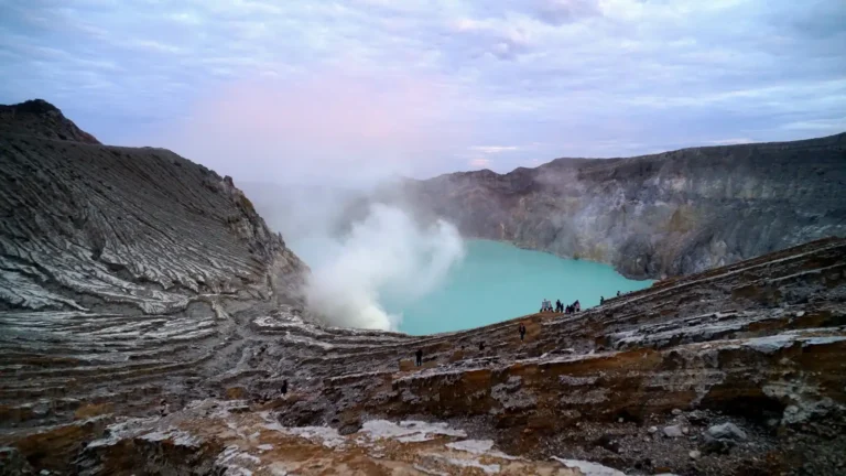
Not all areas of the crater are open for flight. The primary take-off zone is usually located near the “Sunrise Point” or the main rim trail.
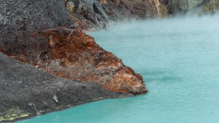
Launching from within the crater itself is strictly forbidden. The Ijen flight zones are designed to keep drones away from the active sulfur vents where visibility is zero.
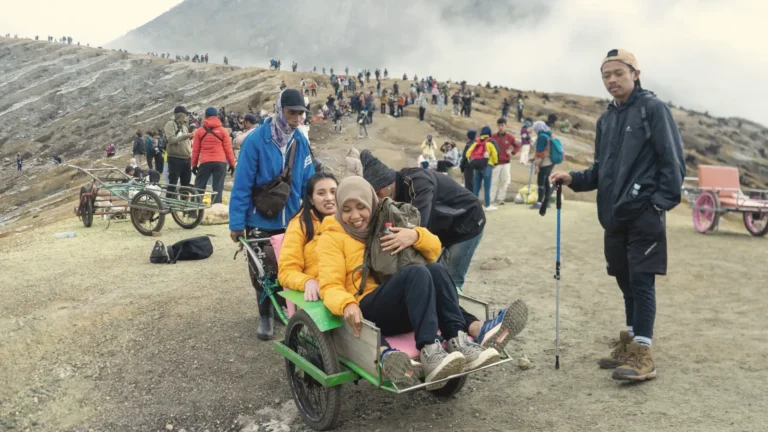
Respecting the Miners
The sulfur miners have the right of way. Their path is narrow, and the work is incredibly grueling. Never hover low over the trolley tracks.
The sound of a drone can be startling and dangerous on a steep cliffside. Keep your distance (at least 30 meters) from any working personnel to avoid distractions.
The best flight path circles the rim from the south, offering a view of the lake without entering the thickest plumes of toxic gas.
Sunrise Congestion
At 5 AM, the rim is packed with hundreds of hikers. Launching a drone in a crowd is a recipe for a propeller-related injury and immediate ranger intervention.
Walk further along the rim towards the less-populated eastern side. You’ll get better angles and a much safer environment for a smooth takeoff and landing.
Always check the wind direction before you launch. If the wind is blowing towards you, the sulfur gas will hit your drone the moment it enters the crater.
Volcanic Hazards for Drones
Ijen is one of the most hostile environments on Earth for electronics. The sulfur gas impact on drones is immediate and often irreversible.
Sulfur dioxide (SO2) reacts with moisture to create sulfuric acid. This acid will eat through the copper wiring and sensitive gimbal motors of your drone.
Signal Interference and GPS Drift
The volcanic rock at Ijen is rich in iron and other minerals. This can cause massive signal interference at Ijen, leading to “toilet bowl” effect or sudden loss of control.
We’ve seen drones fly perfectly one moment and dart toward the crater wall the next. Ensure your “Return to Home” height is set higher than the surrounding peaks.
The crater walls are steep and create significant downdrafts. A lightweight drone like a DJI Mini may struggle to climb out of the crater if caught in a gust.
Protecting Your Gear
After flying, wipe down your drone with a damp cloth to remove any sulfur residue. Do not let the dust sit on the motors or the lens overnight.
Consider using a “conformal coating” on your internal boards if you plan to fly here frequently. For most, a single flight is fine if you stay out of the visible smoke.
Keep your spare batteries in a sealed bag. The acidic air at the rim can penetrate battery vents and cause swelling or long-term damage.
Common Pilot Mistakes
The most common mistake is arriving too late. By 6:30 AM, the sun is high, and the harsh shadows ruin the “moody” volcanic look you’re likely chasing.
Another error is ignoring the Paltuding drone base weather conditions. Just because it’s clear at your hotel doesn’t mean the crater isn’t fogged in.
Battery Management in the Cold
At 2,300 meters, the temperature often drops to 5°C (41°F). Cold batteries drain significantly faster and can cause a sudden power drop mid-flight.
Keep your batteries in an inside pocket close to your body heat until the moment you fly. Calibrate your compass away from the jeep parking lot’s metal frames.
Many pilots forget that the descent back to the Paltuding basecamp takes time. Don’t fly until your battery is at 10%—the wind might fight you on the way back.
Overestimating Skill vs. Nature
Don’t try to fly through the sulfur smoke for a “cool shot.” You will lose visual line of sight, and the acidic mist will likely kill your sensor instantly.
If you lose signal, stay calm. Most drones will hover or return to home. Panic-mashing the sticks often leads to a collision with the jagged crater walls.
For more photography tips, see our guide on Ijen crater photography to nail your manual settings.

Continue Your Adventure
Your journey through East Java shouldn’t end at the Ijen rim. There is so much more to capture from the air in this volcanic wonderland. You might consider combining this trip with a stunning Mount Bromo sunrise tour for iconic “Sea of Sand” shots. If you have more time, a Banyuwangi 2-day tour allows for a more relaxed pace. Don’t forget to contact us today to customize your perfect photography-focused itinerary.
Ready for the Perfect Shot?
Don’t leave your Ijen experience to chance. Between fluctuating gas levels and strict drone permit process rules, you need a partner on the ground who knows the score. We handle the 2 AM wake-ups, the gas masks, and the latest updates so you can focus on your art.
Frequently Asked Questions (FAQ)
Q: Can I buy a drone permit at the Paltuding gate on the morning of my hike?
A: No. While basic recreational fees are paid at the gate, official commercial SIMAKSI permits must be processed in advance at BKSDA offices. Don’t wait until 2 AM to ask for permission.
Q: Is the sulfur gas really that bad for my drone?
A: Yes, it is incredibly corrosive. Even if your drone doesn’t crash, the acidic air starts eating at the copper in your motors immediately. Wipe your gear down thoroughly right after your flight.
Q: What happens if the ranger catches me flying without a permit?
A: Expect immediate confiscation of your drone or memory card. You will likely be fined several million IDR, and in some cases, you may be escorted off the mountain.
Q: Can I fly my drone to see the Blue Fire at night?
A: It is technically possible but highly dangerous and usually discouraged. Visual line of sight is impossible in the dark, and the risk of crashing into miners or the crater wall is extreme.
Q: Which part of the crater rim is the safest for takeoff?
A: The far eastern side of the rim, away from the main Sunrise Point crowd, offers the most space. It also typically has more stable winds than the areas directly above the sulfur vents.